
The 3D map which once stood in the Carl Hayden Visitor Center has a new home at the NHA.
This item is available in full to subscribers.
To continue reading, you will need to either log in to your subscriber account, or purchase a new subscription.
If you are a current print subscriber, you can set up a free website account and connect your subscription to it by clicking here.
If you are a digital subscriber with an active, online-only subscription then you already have an account here. Just reset your password if you've not yet logged in to your account on this new site.
Otherwise, click here to view your options for subscribing.
Please log in to continue |
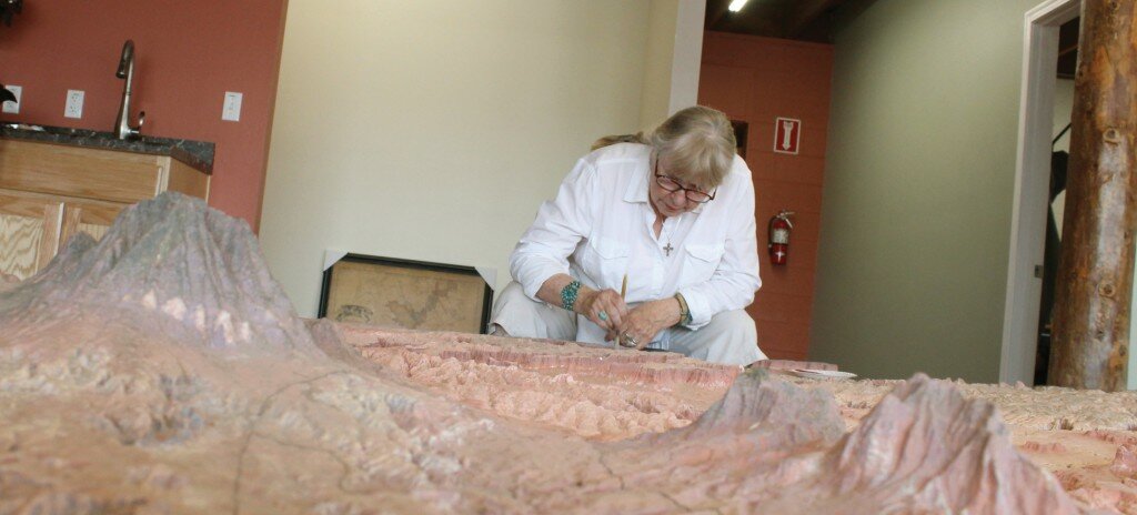
Pat Talbott sits in a chair and leans over a canyon in Canyonlands National Park and sweeps dust out of it with a half-inch paintbrush, using the same careful attention to detail a paleontologist uses removing dust from a dinosaur fossil. A few minutes later she uses tweezers to remove a dried out insect carcass from the bottom of another canyon. She keeps a collection of the various bugs she’s removed from the map on a plastic plate which resides on a table with her map cleaning tools. With Talbott half finished cleaning the map the plate has a couple dozen insect skeletons on it.
Besides the half inch paintbrush Talbott also cleans off the map using a camera lens brush, given to her by her husband Frank, canned air and a sponge.
When Pat comes to a piece that has broken off she reattaches it with glue and fills in any uneven spots using Sculpey, a type of polymer molding clay.
“Tower Butte was loose,” says Talbott. “I put it back on.”
She also paints as she goes. Using acrylic paint she paints over her recently repaired spots, as well as places on the map where the paint has faded or chipped off.
Talbott’s careful dusting, sponging, gluing, sculpting and painting are just the latest in a long series of steps to restore the 3D topo map, which was once housed in the Carl Hayden Visitor Center and now resides in the new digs of the Glen Canyon Natural History Association, which is located next door to the Powell Museum.
The staff of the Natural History Association has already moved into the space and they’ll open their doors to the public in September or October. Visitors will find coffee, books, guide maps, camping gear. Their supply of 7.5 minute topo maps have also returned with maps of the region’s most popular destinations. They’ll have various sections that support the NHA’s various mission.
“We’ll have a dark sky section, a river section, a desert section,” said Cherry Odelberg, retail operations manager for NHA. “Think of it as if REI and Barnes and Noble got together and had a baby.”
And now they’ll have the 3D topo map, which to many locals who once gazed at it when it was housed at the Carl Hayden Vistor Center, is considered a regional treasure.
NHA Director Martin Stamat completely agrees. He is very excited to be the new home for the map.
“It’s not only a treasure, it’s an amazing educational resource,” said Stamat. “When the Bureau of Reclamation offered it to us I thought that I’d be remiss in our duties if we didn’t take it. Most of the visitors who will stand here and look at this map have traveled over a lot of the country to arrive here and they’ll travel over more of it when they leave here. It’s a great way for them to gain a perspective of the terrain through which they’re traveling.”
The area the map shows encompasses 10,000 square miles, or 6.4 million acres. It extends from Marble Canyon, about eight miles south of Lees Ferry north to Canyonlands. It includes such places as Bears Ears, the Paria River, Rainbow Bridge, Navajo Mountain, The San Juan River, Capital Reef National Park and much of the Colorado River, to name just a few.
The 3D map was hand carved, not molded, from isocyanate foam in 1967 by Robert S. Miller. He did the fine carving with dentist tools. It took him 279 eight-hour work days, or 1,952 hours, to carve the map, and another 698 hours to paint it. The map was constructed in seven different sections.
The map shows Lake Powell when it’s at full pool or 3,700 feet above sea level. One and a half inches on the map equals one mile of real terrain. One inch of vertical elevation on the map equals 1,280 feet in real terrain.
For Talbott, cleaning and mending the map is a labor of love. In a very real way this map inspired her to move to Page so she could further explore the beautiful terrain displayed on the map.
“I’ve been looking at this map for two and half decades,” said Talbott. “The first time I saw it was in 1994 when I came here to visit a friend from high school. I went home and told Frank `I found the place I want to live the rest of my life.’
“I was in tears when they took it apart and took it away. I thought I’d never see it again. My heart was breaking.”
Being an artist herself Talbott really appreciates the amount of time, effort and workmanship the map’s original artist, Robert Miller, put into it.
Talbott says she often uses Google Earth to more thoroughly search some of the places on the 3D map.
“I find little divots on the 3D map and I don’t know if they exist in real life, or if it’s a flaw on the map,” she said.
If it’s a flaw she fills it in. Talbott’s biggest challenge will be filling in the seams where the map connects. When the map was dismantled big flakes and chips broke off.
She’ll use Sculpey and paint and images from Google Earth to restore them.
Sam Riggs, a welder with Page Steel, is creating a metal border for the map.


