Comprised of harsh topography and climatic extremes, the Old Spanish Trail has been called one of the most difficult trails in America.
This item is available in full to subscribers.
To continue reading, you will need to either log in to your subscriber account, or purchase a new subscription.
If you are a current print subscriber, you can set up a free website account and connect your subscription to it by clicking here.
If you are a digital subscriber with an active, online-only subscription then you already have an account here. Just reset your password if you've not yet logged in to your account on this new site.
Otherwise, click here to view your options for subscribing.
Please log in to continue |
Nearly 200 years ago, a Mexican trader named Antonio Armijo crossed the Colorado River with his mule caravan and traversed the rugged landscape between Page and Kanab. Packing a precious cargo of woolen goods, this merchant began his journey on Nov. 6, 1829 from Abiquiu, New Mexico, with the goal of reaching the pueblo of Los Angeles to trade blankets and other products of New Mexico for California horses and mules.
Successful in reaching the San Gabriel Mission in California on Jan. 31, 1830, Armijo confirmed important new trade opportunities. His success started a tradition of annual Mexican caravans leaving Santa Fe in the fall to cross rivers, rugged canyons and the desolation of the Mojave Desert in the winter months before reaching the fertile fields of California.
The route, now known as The Old Spanish Trail and declared a national historic trail by Congress in 2002, linked Mexico’s two most important northern provinces. Separated by harsh topography and climatic extremes, and despite attempts beginning as early as the failed 1776 Dominguez-Escalante expedition, it took another 53 years before the trail was successfully opened to nearly annual trips by those who followed Armijo. The Old Spanish Trail has been called the most arduous, difficult land crossing in the United States.
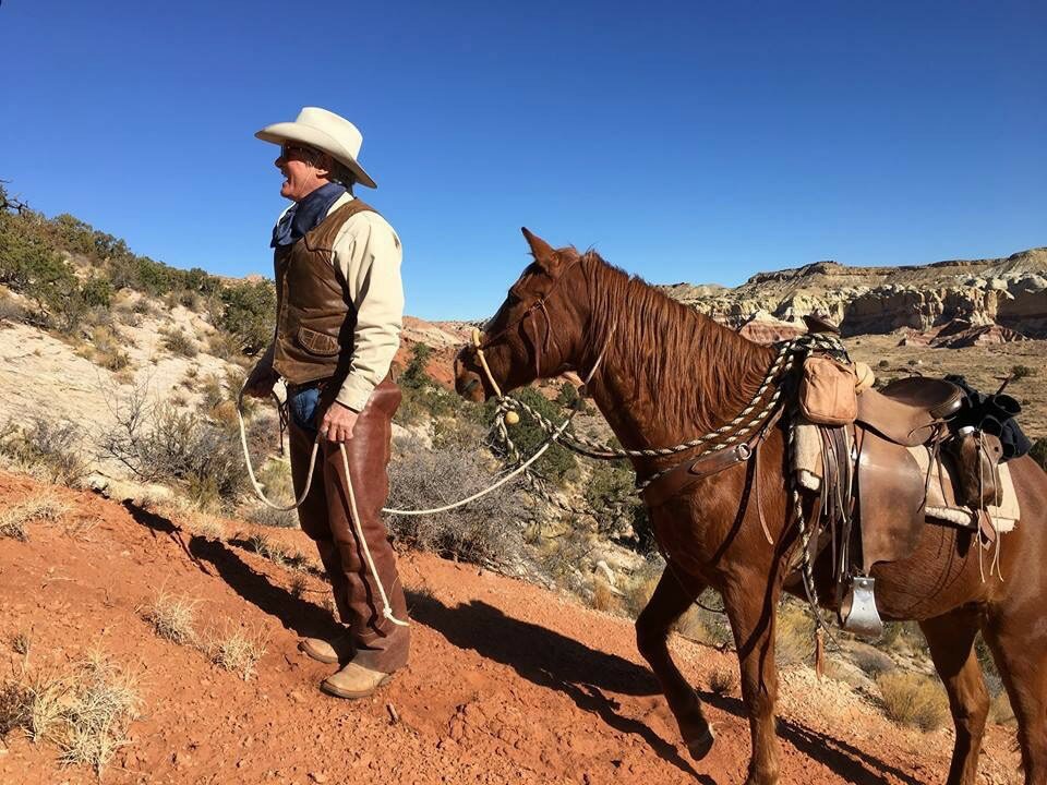
To commemorate the exact date of Armijo’s first trip across the local Page area, three members of the Old Spanish Trail Association, accompanied by a BLM backcountry ranger, gathered on Dec. 10, 2017, to consider various translations of the Armijo diary and re-enact a section of trail corridor near the Paria River and the formidable Cockscomb formation riding horses and a mule.
Finding Armijo’s exact trail remains troubling for researchers even today. There are several possible routes Armijo may have used. The Association field trip was part of grant and cooperative agreement with the BLM Arizona Strip Office with the objectives of refining historic route/trail alignments between Page and Littlefield, Ariz., and to make recommendations regarding recreational trail opportunities and signage so that the public can vicariously experience the essence of the Old Spanish National Historic Trail.
Using Armijo’s descriptions of land formations, Old Spanish Trail Association Secretary Paul Ostapuk, Red Pueblo (Kanab) Chapter President Jeff Frey, BLM Ranger Travis Legler and this reporter attempted to interpret Armijo’s sketchy journal and access the feasibility of trail corridor options perhaps traversed by the original mule caravan. The Cockscomb presented a steep geological barrier of several hundred feet that was not insurmountable but likely difficult with 100 head of heavily laden livestock. Our goal was to determine if an alternative shortcut route could have been used; a route originally noted in an 1869 journal prepared by the Utah Territorial Militia who initially traveled through the Box of the Paria River enroute to the Colorado River but noted a through-the-Cockscomb shortcut on their return leg.
The Armijo diary is silent as to the exact route chosen by the 1829 caravan.
December 10, 1829 – At the artenejal de la ceja Colorado.
December 11, 1829 – At the creek of canyon de la ceja
The word “ceja” is a specific reference to an eyebrow ridge, a good description of the Cockscomb Kaibab monocline. The word “artenejal” is loosely translated as rimrock but there is debate as to the exact location of the December 10th campsite and whether the Armijo caravan travelled along the Paria river to the north or took a short cut through the Cockscomb
We selected a route parallel to and within sight of U.S. 89. Travis’ 11-year-old mule Dusty, who regularly carries Travis throughout the Vermillion Cliffs and BLM backcountry, had little trouble negotiating the steep, loose sandstone and sandy slope. Despite my Navajo mustangs’ sturdy builds, 24-year-old Lady and her 19-year-old filly Sandy needed to be led up the slope by Jeff and I.
The recently released Old Spanish National Historic Trail Comprehensive Administrative Strategy dated Dec. 18, 2017, officially shows the Armijo route following north along the Paria River where it is listed as a “high potential segment.” These are identified trail that “afford high-quality recreation experiences along a portion of the route having greater-than-average scenic values or affording an opportunity to share vicariously the experience of the original users of a historic route.”
More information on the Old Spanish Trail is available at the association website at oldspanishtrail.org. With OSTA chapters across the Southwest, the Armijo Chapter based in Page is unique because it is a section of the trail used for a single round-trip in 1929-1930.
George Hardeen is president of the Armijo Chapter of the Old Spanish Trail Association.


