The Glen Canyon Conservancy Lecture Series on Sept. 14 presented “Navajo Bridge Connecting People and Policy” at the Navajo Bridge Interpretive Center.
This item is available in full to subscribers.
Attention subscribers
To continue reading, you will need to either log in to your subscriber account, or purchase a new subscription.
If you are a current print subscriber, you can set up a free website account and connect your subscription to it by clicking here.
If you are a digital subscriber with an active, online-only subscription then you already have an account here. Just reset your password if you've not yet logged in to your account on this new site.
Otherwise, click here to view your options for subscribing.
Please log in to continue
Need an account?
Print subscribers
If you're a print subscriber, but do not yet have an online account, click here to create one.
Non-subscribers
Click here to see your options for becoming a subscriber.
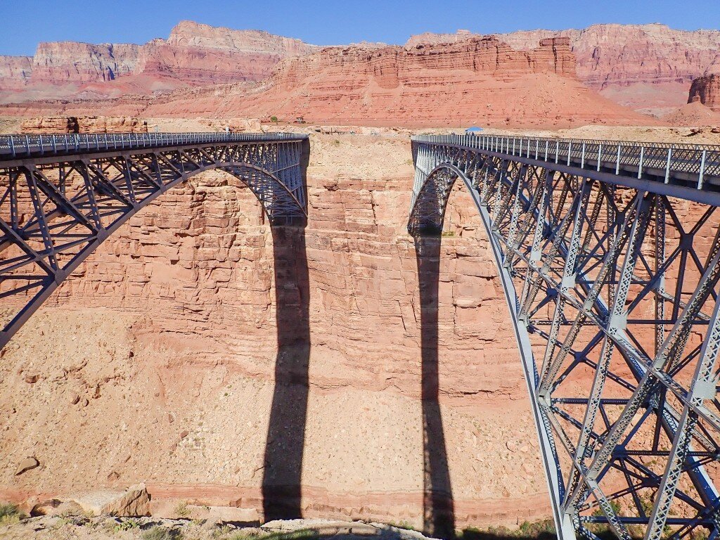
Navajo Bridge connecting people, policy
The 1929 bridge, left, and the 1995 bridge on the right above the Colorado River in Marble Canyon, Arizona. Echo Cliffs in the background.
Posted
Phil Clark
By Phil Clark Lake Powell Chronicle
MARBLE CANYON, Ariz. – The Glen Canyon Conservancy Lecture Series on Sept. 14 presented “Navajo Bridge Connecting People and Policy” at the Navajo Bridge Interpretive Center.
The parking lots were full, and visitors enjoyed the beautiful late summer day strolling along the old bridge. Instead of the conservancy presentations that many Page residents are accustomed to attending at the Page Community Center, this one was more informal and allowed visitors to experience the historic site. It was as if the conservancy even had arranged for a condor to sit on the “new” bridge for visitors to see. Perhaps it was wondering why there were so many more people around.
Prior to either bridge being built, there was actually a ferry at Lees Ferry that would take people and equipment across the Colorado River. Back then, there wasn’t the Glen Canyon Dam and the river levels rose and fell with the waters flowing from the mountains. Sometimes the river was too low to allow the ferry to cross. Other times the river was flowing with such fury, that the ferry could capsize from the high flows and had to wait for safer waters. People would travel down a dugway road to the Colorado River from the east and take the ferry across.
The ferry was originally started by John D. Lee and operated from 1873 to 1929, allowing Mormon pioneers and others to settle in northern Arizona and in southern Utah until the original bridge was completed.
When the original Navajo Bridge was completed, in 1929, it was called the Grand Canyon Bridge since it crossed the upper reaches of Grand Canyon National Park. At that time, it was the highest steel arch in the world. The public soon demanded that the name be changed.
Proposed names included, “Lees Ferry Bridge” and “Navajo Bridge.” The bridge was renamed the Navajo Bridge in 1934 and remains today. The original bridge might have been adequate when it was first built but as the 20th century was coming to an end; it was deemed unsafe and unable to handle the increased and heavier modern traffic. Modern road standards called for each lane of traffic to be 12 feet wide. The original bridge was only 18 feet wide, for two lanes and shoulders, which was hardly wide enough for two vehicles to pass much less have room for someone to stop and take photos of the canyon below. Many, including this reporter, used to quickly snap a photo, well aware of the danger while determined to take a photo.
The state of Arizona recognized, in the 1980s, that the original bridge was unsafe for both pedestrians and modern-sized vehicles. There were three other alternative locations chosen for the bridge, all down canyon from the current location. One of the alternatives would have eliminated the historic masonry view point. Nearby Native American tribes adamantly objected to the removal of the historic view point. Environmental groups opposed any other location than next to the existing bridge. At the conclusion of the planning phase, the new bridge was located where it is now, allowing visitors not only to enjoy the historic view point but also be able to see the river and the new bridge from the original bridge.
The new Navajo Bridge in 1995 was opened to the public, after 10 years of planning, design and construction. The original bridge was converted to a pedestrian-only bridge. The new bridge design, while wider and structurally capable of handling modern traffic, resembles the original bridge in style and design. Rocks were not allowed to fall into the river, which was one of the more challenging construction requirements. All rocks had to be removed and were placed nearby along the road east of the bridge. The original bridge was assembled with rivets, a technique that is no longer used in steel construction. High strength bolts and steel girders were used in the new bridge.
Pauline Wilson, a resident of Bitter Springs and a former coworker with this reporter, greeted visitors on the east end of the bridge and talked about the concerns the Navajo Nation had during the planning of the new bridge. Wilson said she played a crucial role in the planning and design of the new bridge, serving as an interpreter in discussions between the Nation, Arizona Department of Transportation, Project Consultant, and the National Park Service.
Her grandfather, John Deering (Bįįh Bitoodnii Nez in the Navajo language) transported supplies and the mail from Flagstaff to Salt Lake City. He also operated the ferry at Lees Ferry and maintained the trail to the bottom of the canyon until the original bridge was opened. Future plans for the east end of the bridge is a more formal welcome center. Currently, there is room for five Native vendors. Vendors are chosen based on a lottery with as many as 100 vendors applying to sell their wares. A nonprofit manages the lottery and the money raised is used for scholarships and community service projects.
Jerry Cannon, whose consulting firm was contracted by the Arizona DOT for the planning, design and construction of the newer bridge talked about the engineering challenges of building the second bridge. He shared copies of the original construction plans for both bridges as well as some photos of the construction of the new bridge.
In addition to the drawings, he showed visitors a rivet that had been used in the original bridge as well as a core sample of the limestone rock that was taken to make sure the foundation for the new bridge was solid. Both bridges soar some 470 feet above the Colorado River while others are over 830 feet long.
Kathy Hays greeted visitors at the historic view shelter on the west side of the bridge. According to Hays, a man named Woodward designed the historic shade structure and it was built by the Civilian Conservation Corps in the 1930s, allowing visitors the opportunity to stop and look at the bridge and the river canyon without walking on the bridge.
Navajo tribal masons helped with the construction of the stone walls at the historic shelter. Visitors back then could take a trail down to a lower level and view the bridge and the river.
That trail has long since been obliterated. Relocated bronze plaques from the trail are now easier to see, next to the historic view shelter.
As part of the new bridge construction, the Navajo Bridge Interpretive Center and restroom facility was constructed to resemble the stone and masonry techniques used in the original view shelter.
Men with the CCC and local crews worked together to build the shelter. Most visitors might find it difficult to tell the difference between the old and new masonry structures.
Today, many motorists drive across Navajo Bridge oblivious to how difficult it had been, less than 100 years ago, to cross the Colorado River and what it took to build a new bridge to handle modern-day traffic while also protecting and preserving the original bridge and masonry structures.
It is well worth the stop for a short walk across the historic bridge to see views of the Vermilion Cliffs, Colorado River, and to possibly see a condor or two, perched on the new bridge.
Visitors are treated to Native American jewelry and crafts on the east side and on the west side, as well a stocked gift shop which provides visitors a wide choice of books, clothing and souvenirs, and a restroom that uses no water.