
The map was hand-carved in 1967 by Robert Miller.
This item is available in full to subscribers.
To continue reading, you will need to either log in to your subscriber account, or purchase a new subscription.
If you are a current print subscriber, you can set up a free website account and connect your subscription to it by clicking here.
If you are a digital subscriber with an active, online-only subscription then you already have an account here. Just reset your password if you've not yet logged in to your account on this new site.
Otherwise, click here to view your options for subscribing.
Please log in to continue |
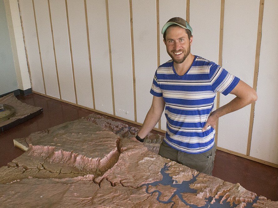
The famous, hand carved relief map – considered a public treasure by many – that once occupied prime real estate in the Carl Hayden Visitor Center, has found a new home with the Glen Canyon Natural History Association (NHA).
The map is considered a masterpiece of craftsmanship and it was the centerpiece and star of the Carl Hayden Visitor Center exhibits.
The map is roughly 15 x 19 feet across. When assembled it standsknee high to an adult. It was hand carved, not molded, from isocyanate foam in 1967 by Robert S. Miller. He did the fine carving with dentist tools. It took Miller 279 eight hour work days, or 1,952 hours, to carve the map, and another 698 hours to paint it. The map was constructed in seven different sections.
Officials at the Bureau of Reclamation (BOR) had the map dismantled and removed a few years ago to make room for their current installation which features more updated, STEM-based information. The BOR has been storing the map in their warehouse since then.
“It was such a beloved feature in the Carl Hayden Visitor’s Center,” said Martin Stamat, director for the Glen Canyon Natural History Association (NHA). “People were pretty sad when this tremendous map was removed.”
“When the BOR approached us and asked us if we’d like the map we jumped at the chance,” said Stamat.
The map will be displayed at the NHA’s new facility on Lake Powell Boulevard, located next door to the Powell Museum. Displaying the map will reduce the NHA’s retail space in half but Stamat believes it will enhance their visitor’s experience and understanding of the region they’re passing through.
“It’s an amazing resource that shows visitors the context of the region, Page and canyon country,” said Stamat. “I don’t think this map could have found a better home. It will help us to better share our interp and present the public lands we support. I’m really happy it’s here.”
The NHA’s new facility will feature a storefront and visitor center up front, with office space for its employees in the back and storage space in the very rear of the building. They hope to open the new space by the Fourth of July.


